When we think about the weather in Greyton, we tend to look at the mountains, the clouds rolling in from the coast, or the cold fronts approaching from the south. It can therefore seem strange that a patch of warm ocean water thousands of kilometres away in the Pacific Ocean could have any influence on our weather at all.
Yet it can.
One of the most important climate patterns on Earth is known as El Niño, Spanish for “The Boy” or “The Christ Child.” Together with its opposite phase, La Niña (“The Girl”), it forms part of a natural climate cycle known as the El Niño-Southern Oscillation (ENSO) that influences weather across much of the globe – including here in South Africa.
Where do the names come from?
The names were first used by fishermen along the coast of Peru. They noticed that unusually warm ocean waters often appeared around Christmas time and named the phenomenon El Niño, referring to the Christ Child. The opposite phase, which is generally associated with cooler ocean temperatures in the eastern Pacific, later became known as La Niña.
What is El Niño?
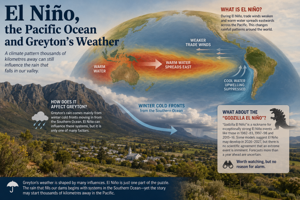
Under normal conditions, strong trade winds blow across the tropical Pacific Ocean, pushing warm surface water towards Australia and Southeast Asia. This allows cooler water to rise to the surface off the coast of South America.
During an El Niño event, those trade winds weaken and warm water spreads eastwards across the Pacific. This changes ocean temperatures and shifts rainfall patterns across large parts of the world. Although it happens thousands of kilometres away, the atmosphere is connected, and changes in one region can influence weather systems elsewhere.
Think of it as dropping a stone into a pond. The ripple spreads far beyond where the stone entered the water.
How does it affect South Africa?
El Niño is often associated with hotter and drier conditions across much of South Africa, particularly the summer rainfall regions of the interior. Farmers in provinces such as the Free State and North West pay close attention to El Niño forecasts because of the impact they can have on crops and water supplies.
The Western Cape, however, is different.
Our rainfall comes mainly from winter cold fronts moving in from the Southern Ocean. As a result, the connection between El Niño and rainfall in Greyton is much weaker and less predictable than it is elsewhere in the country.
What about the “Godzilla El Niño”?
Recently there has been considerable discussion online about a possible “Godzilla El Niño”. This is not an official scientific term but a nickname given to exceptionally strong El Niño events such as those experienced in 1982-83, 1997-98 and 2015-16.
Some long-range climate models suggest El Niño conditions may redevelop during 2026 and 2027, but there is currently no scientific agreement that an extreme event is on the way. Forecasting El Niño more than a year ahead remains difficult, and climate scientists are cautious about making strong predictions that far into the future.
In short, it is worth watching, but there is no reason for alarm.
What does this mean for Greyton?
At present, the Pacific Ocean is in a neutral phase, meaning neither El Niño nor La Niña is active. Some forecasts indicate that El Niño conditions could begin developing during the coming year, although confidence remains limited.
For Greyton and the Overberg, El Niño is only one piece of a much larger puzzle. A strong El Niño does not automatically mean drought here, just as La Niña does not guarantee abundant rainfall.
The weather that fills our dams and greens our hillsides is still largely determined by the winter cold fronts arriving from the Southern Ocean. However, the conditions influencing those fronts can sometimes begin with changes taking place thousands of kilometres away in the Pacific Ocean.
It is a reminder that while Greyton may feel like a small corner of the world, it remains connected to a much larger and fascinating climate system.